You are here
Your Water Supply
A water system works in a similar way to the global water cycle — connected parts all work together to continuously move water, meeting the needs of water users along the way. Water systems exist both with and without human influence. Water systems without human influence may be thought of as groundwater and surface water moving throughout a watershed, storing and releasing water into the environment. These natural processes are mimicked by engineering infrastructure to transport, clean and deliver water often hundreds of miles through a water system of pipes, canals and reservoirs. Infrastructure to deliver water dates back thousands of years and is integral to maintaining the many functions of today’s complex societies.
How Watersheds Work
All of the land area on the planet is organized into watersheds that are defined by natural topography and hydrology. Watersheds, also known as basins, catchments or drainages, are made up of all the land area that drains to an outlet or a single low-point in the watershed. Watersheds are nested in larger watersheds as creeks and tributaries flow into larger rivers, creating an entire river system. This nesting is similar to how cities are nested within county boundaries, counties within states and states within countries. The boundaries of a watershed are defined by high points of elevation, which cause water to flow a certain direction. While the movement of water is influenced by topography, such as mountains, valleys and hills, all of the water falling within a single watershed will flow downhill toward a stream, river, lake or closed basin — in other words, toward an outlet or shared destination.
Although all watersheds work to store and release water, conveying water downhill toward drainage areas, these functions are influenced by both natural and human drivers. Natural factors that affect watersheds include their shape and size, slope steepness and orientation, climate, geology, elevation, vegetation cover and soil type. Combined, these characteristics work together to create a variety of watershed responses that affect the habitats, species and ecosystems within a given watershed.
Due to their natural boundaries, watersheds create a logical approach to managing land and water resources. A multitude of stakeholders such as scientists, natural resource managers, city and town officials, planners, land owners (both private and public landholders), ranchers, industry officials, and developers may be involved with making decisions that influence the health of a watershed. Political boundaries often cut across watershed boundaries, creating challenges for managing watersheds effectively over different jurisdictions with possibly differing interests. Land management activities including mining, forestry, recreation, grazing, fires, agriculture and urbanization can impact how a watershed functions, potentially altering the amount of water that enters and moves through a watershed. With so many natural factors and players involved with managing a watershed, it becomes clear how changes to the functions and land uses within a watershed can affect many other users and functions within these highly-connected systems.
How Aquifers Work
About 30 percent, or 2.78 million trillion gallons, of the world’s freshwater is stored as groundwater in aquifers. Aquifers are naturally occurring underground water storage systems that form when the space around underground soil or rock is saturated with water. The upper limit of this saturated zone is called the water table. Similar to watersheds on the land surface, aquifers convey water underground, moving water from zones of high to low pressure or down gradient. The type and size of unconsolidated material (the soil or rock) influences the speed of water movement within the aquifer. Because smaller pore spaces hold water more tightly than larger pore spaces, infiltration rates, permeability, and storage capacity are all affected by aquifer characteristics. Aquifers are bounded by confining layers made up of non-porous material that restricts water movement outside of the aquifer. Confined aquifers are those that are completely enclosed by this non-porous material.
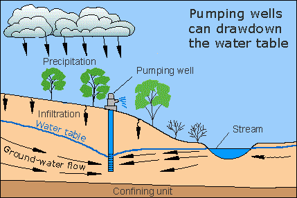 Water can enter an aquifer through natural recharge (rainfall and infiltration) or artificial recharge (manmade injections and intentional slowing and detention of water to encourage infiltration). Similarly, water can naturally exit an aquifer (via pressure in the form of artesian wells or outflow to a stream where the water table connects with the ground surface) or through human influence (groundwater pumping). When water leaves an aquifer faster than it is replaced, water tables begin to decrease or fall farther below the ground surface. Openings are created in the previously saturated pore space and these openings may collapse and cause the ground to sink in a process known as subsidence. A cone of depression occurs when the water table surrounding a well is lowered due to groundwater pumping. This drawdown creates a cone-shaped area where the ground is no longer saturated. Falling water tables can increase groundwater pumping costs, as well as disconnect surface and groundwater resources that may impact river and riparian ecosystems.
Where Drinking Water Comes From
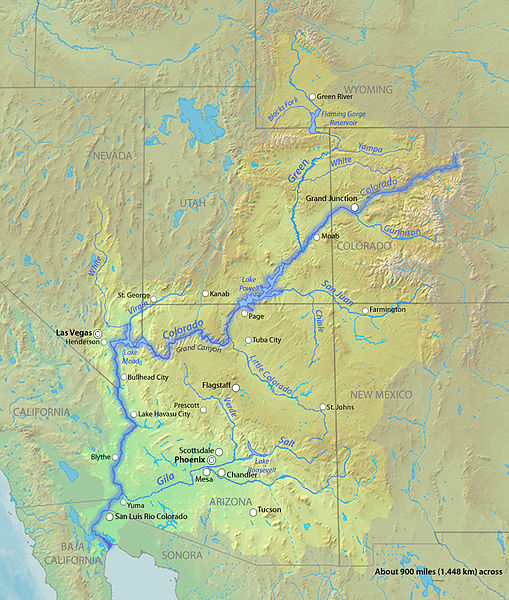
One of the most heavily-tapped water sources in southwestern United States and northern Mexico is the Colorado River Basin. The Colorado River Basin has a land area that extends into seven states and Mexico and covers 242,000 square miles in the U.S. and 2,000 square miles in Mexico. The watershed begins in the Rocky Mountains of north central Colorado and flows 1,450 miles southwest, eventually draining into the Gulf of California in Mexico. Many populated areas in the Colorado River Basin rely on water imported from the Colorado River for part or all of their water supply. Due largely to this high demand for the resource, the Colorado River flow currently stops about 50 miles short of the Gulf; this situation has had serious impacts on the habitat, economy, and way of life in northwestern Mexico.
 Within the basin, municipalities may use other sources of water that include groundwater, local surface water and reclaimed water. Except for reclaimed water, all of these water sources are usually mixed and treated together at a water treatment plant, and then delivered throughout the service area. The ratio of blending may change seasonally or by water treatment location and is always carefully monitored. Groundwater is pumped out of an aquifer and piped to the treatment plant, while local surface water is often diverted directly from a river and delivered through pipes or canals to the treatment plant. Once water is treated, it is channeled into underground pipes to maintain quality; this water is monitored throughout the delivery system. A good way to visualize the water delivery system is to think about the blood vessels in a body or a river system in reverse. Water leaving the treatment plant is initially conveyed in large pipes many feet in diameter and then the distribution system breaks off into smaller and smaller lines as it moves away from the treatment plant. When it enters your home it is flowing through a 1 inch or 5/8 inch pipe.If you’ve never thought about where the water supplied to your home comes from, it’s an interesting exercise to trace water flowing out of your tap back to its original source. You may find that it was pumped out of the ground within your community or that it has traveled hundreds of miles through pipes and canals — or both. While we all know how important water is, understanding the engineering, construction, continuous maintenance, costs and other resources (e.g. energy) required to create a reliable water supply makes us appreciate this resource even more.
To better understand where our water comes from, let’s look at the water systems in Tucson, Arizona and Denver, Colorado, two examples from different locations in the Colorado River Basin.
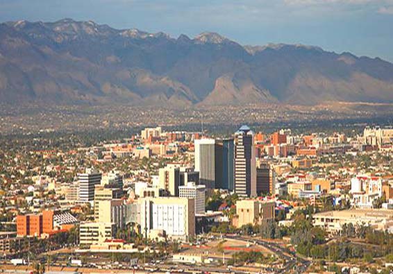 Tucson, Arizona Example: Tucson was once famous for being the largest city in the country completely dependent on groundwater. Unfortunately, although usually local in nature, groundwater supplies are considered non-renewable because it takes much longer for water to recharge the aquifer than it does to pump water out of the aquifer. The completion of the Central Arizona Project (CAP), which transports water from Lake Havasu to Phoenix and Tucson through 336 miles of canal, provided a renewable supply of water for Tucson. The transport of water from the Colorado River uphill nearly 3,000 feet to Phoenix and Tucson requires a tremendous amount of energy. As a result, the CAP is also the state’s largest user of energy, as well as the largest supplier of renewable water.
Once this water reaches Tucson it is recharged back into the ground at recharge facilities where the Colorado River water mixes with local groundwater. Production wells recover this blended water and take it to the water treatment plant for treatment before it is delivered to customers. Of the total 2.8 million acre-feet allocated to Arizona and 1.5 million acre-feet that actually flow through the CAP each year, Tucson has an allocation of 148,420 acre-feet. In 2012 Tucson Water delivered 93,250 acre-feet (33.9 billion gallons) of potable water to 709,000 customers. Tucson Water's potable system covers a 350 square-mile service area and is composed of more than 200 active production wells, 4,300 miles of delivery pipelines, 124 boosters to move water around the delivery area, and 65 storage facilities capable of storing nearly 280 million gallons of water. Over 90% of Tucson Water’s potable (safe for consumption) demand was met with recovered CAP water and only 10% with groundwater -- so Tucson no longer has the claim to the largest city in the country completely dependent on groundwater. In addition to the potable water supply, 12,500 acre-feet of reclaimed water (water treated at the wastewater treatment plant) is used to irrigate golf courses, parks and schools throughout Tucson, bringing total deliveries to 104,037 acre-feet in 2012.
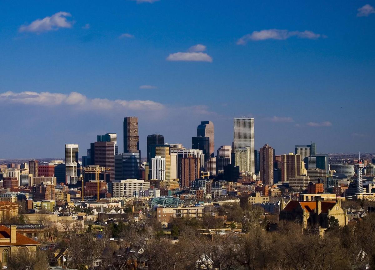 Denver, Colorado Example: Located much higher in the watershed, Denver has more direct access to water in the Colorado River and its tributaries. The majority of Denver’s water comes from rivers and streams fed by mountain snowmelt, and it is entirely gravity fed, meaning little energy is needed to transport this water. The South Platte River, Blue River, Williams Fork River and Fraser River watersheds are Denver Water’s primary water sources, but it also uses water from the South Boulder Creek, Ralston Creek and Bear Creek watersheds. There are 15 reservoirs split into three systems (South Platte, Moffat and Western Slope) that store and release water to Denver, as well as provide recreational opportunities. These reservoir systems collect water from a land area covering 4,000 square miles (2.5 million acres). In total these reservoirs have a capacity of almost 700,000 acre-feet of water; Dillon Reservoir on the Western Slope system is Denver Water’s largest storage facility, holding nearly 40 percent of Denver’s water.
Water Infrastructure
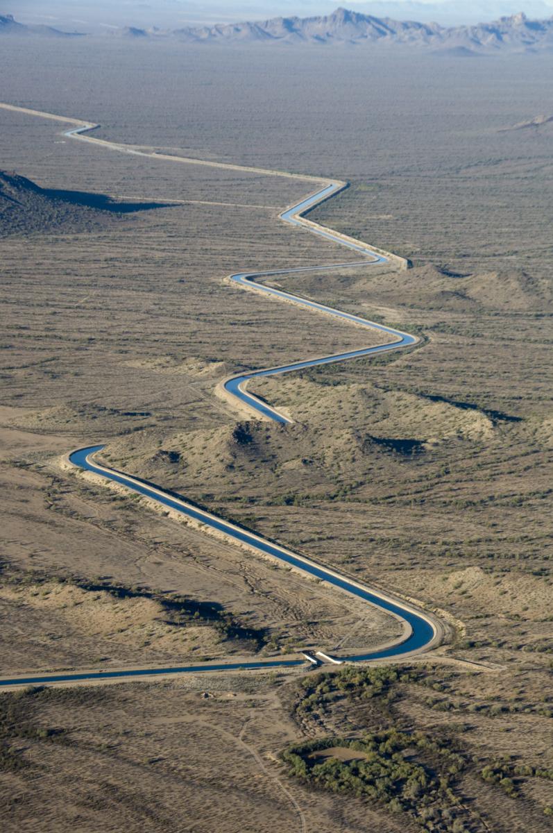 |
| Central Arizona Project canal transporting Colorado River water |
40 million people depend on water from the Colorado River and most of the water to meet this demand is transported to population centers hundreds of miles away from the main stem of the river. Moving this water requires advanced infrastructure to ensure that the correct amount of water is transported, treated and delivered at any given time throughout the 250,000 square mile watershed. Too much or too little water could result in disastrous consequences for the river and downstream communities.
Throughout the journey from the Colorado River’s headwaters to the Gulf of California water is stored, diverted and returned back to the river. Along its journey, water is stored in reservoirs, then diverted into canals, aqueducts, tunnels and pipelines for agricultural uses, hydroelectric production and municipal and industrial deliveries. At the same time water is put back into the river through wastewater treatment and agricultural return flows. In fact, in an average year, a drop of water from the Colorado River water is used and reused seventeen times. More than 100 dams have been built along the entire river system and today there are 29 major dams along the Colorado River, significantly altering the time and quantity of flows throughout the basin.
Water Treatment
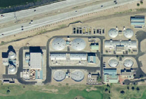 |
| City of Mesa Water Treatment Plant |
Water deliveries from a utility service provider are closely monitored to ensure that their customers receive safe water supplies. Treatment processes will vary depending on the quality of the water source and the desired end use. For example, water that comes from a secure groundwater supply may only need to be filtered and chlorinated before delivery where a surface water supply will require many more steps to clean up the debris and contaminants that open bodies of water are prone to. Similarly, water destined for agricultural irrigation will not have to meet the same safety standards as drinking water being delivered to a home. The U.S. Environmental Protection Agency (EPA) regulates drinking water quality standards to ensure public safety.
A typical water treatment process will involve four major steps: (1) coagulation—a chemical is added that sticks to suspended particles; (2) sedimentation—the bound particles sink from the added weight; (3) filtration—water passes through a series of filters that can be made of sand, charcoal, or even biological material; and (4) disinfection—may be through chemical addition (e.g. chlorine) or the use of UV lights or ozone.
Water and Energy
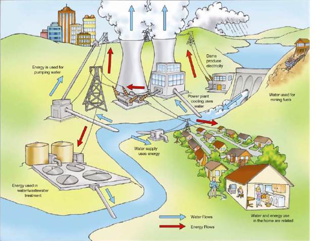 The ‘water-energy nexus’ is a phrase that’s been coined in the last several years to describe the interdependent relationship that water and energy have on each other in terms of the use and production of both resources. Water requires electricity to be transported (e.g. the Central Arizona Project), treated and pumped out of the ground and uphill. When consumers use less water, they are also using less energy.
Conversely, the production of energy requires water; nationally power production accounts for 41% of all freshwater withdrawals. Water is primarily used in cooling processes at thermoelectric power plants that use coal or gas for electric generation. Water is also evaporated from reservoirs that generate hydroelectricity, used to extract, transport and process fuels and for irrigation to grow biomass feedstock crops. The amount of water used varies depending on the type of electricity being produced, but in the Southwest thermoelectric power production uses 0.32 gallons/kWh of electricity produced. Just like with water, using less electricity also uses less water.
The infrastructure to deliver both water and electricity long distances already exists and new delivery and transmission systems can be built; however large infrastructure projects are expensive, sometimes prohibitively so, and require additional resources. The farther that water is transported, the more energy is required, and producing more power to meet increased demand also increases the need for water. These feedback cycles that exist between water and energy illustrate that resources are not unlimited and that conservation is an integral part of ensuring reliable energy and sustainable water supplies.